Forest fires and wildfires have been much in the news lately. What is your research focused on?
I’m lucky enough to be doing research into a phenomenon that appeals to the imagination. The news has given a lot of attention to wildfires, especially in the last few years, and this has given rise to the idea that fires are always bad for nature. While this is certainly true in the Netherlands, in many other regions wildfires often play an important and positive role: in certain ecosystems, periodic fires are essential because they prevent uncontrolled growth and therefore reduce the likelihood of huge, devastating fires.
My own research focuses more on the dynamics of these fires. Questions like: where do wildfires occur? Have they become more frequent over the years, or less? What kinds of emissions do they produce? And an important related question: what effect does climate change have on wildfires, and – of course – how do wildfires affect the climate? This last question, the interaction between climate and wildfires, is a very interesting one. Put simply, wildfires are basically climate-neutral: in principle, the CO₂ emitted by a wildfire is compensated later as vegetation re-establishes itself, absorbing CO₂ as it grows. However, if wildfires occur more frequently, for instance because of climate change, then that principle no longer applies because the vegetation has less time to recover.
Was there already significant societal and scientific interest in wildfires when you started this research?
My scientific field has grown rapidly in recent decades. When I started my career, around 2000, there was an annual earth sciences conference in the United States that had just passed the ten thousand science participant mark. Today it’s three times that number. Research into forest fires has also seen rapid global growth, including in the Netherlands. Early on I was one of the very few to be looking at wildfires from a climate perspective, but today there are lots of first-rate scientists looking at different aspects of these fires. Societal interest has also grown, partly because extreme fires are occurring more frequently, but also because of the rise of social media.
How did you end up researching this topic?
More or less by accident. I was studying Physical Geography at Vrije Universiteit Amsterdam. One of the last courses I took was on the use of satellite data. I found it really fascinating, so I asked the professor if he knew of an internship that would let me go into the subject more deeply. Thanks to his contacts I was able to join NASA in the United States and work there as a junior researcher. They’d just launched a new satellite that was also mapping fires, and they needed someone to help use the wildfire data this satellite was providing in order to programme a climate model.
Did your work experience at NASA influence the direction of your own research?
The satellite that NASA launched twenty-five years ago is still circling the Earth today. We were collecting and processing its data, and that data ultimately formed the basis of my subsequent scientific career. It’s pretty remarkable to have been able to collect consistent global data for such a long time. After all, as a scientist, you’re heavily dependent on the quality and continuity of your data. Of course, these days we have better satellite data, imaging the Earth in greater detail. But thanks to this unique and consistent twenty-five-year series we know, for instance, that wildfires have become less frequent in many tropical areas and are becoming more frequent in the high north.
When I came back to the Netherlands to complete my PhD, I worked within a research team to figure out how much vegetation was being lost globally to wildfire every year, based on the satellite data. During this research, I noticed that many other researchers were interested in the data we could provide, and that eventually led to the creation of the Global Fire Emissions Database (GFED). Over the years this database has been continuously extended.
Could you explain what this Global Fire Emissions Database comprises?
The database is one piece of the puzzle in broader research into the climate system. Through satellite observations and ground-based measurements, data is being continuously collected all over the world to refine the database. This requires co-operation between different international research groups, each with their own area of expertise. Some teams focus on the impact of wildfires on local vegetation, for instance, while others look at the relationships between the various gases being emitted. All these different measurements are added to the database, and the data is then used by researchers all over the world.
The database design itself is fairly straightforward. For any given day, anywhere in the world, we want to know: did a fire occur anywhere? If so, how big was it? And what gases did it emit? But behind these simple questions lies a wealth of complexity.
For instance, the composition of wildfire emissions strongly depends on the type of ecosystem in which the fire occurred. Grassland wildfires generally release different, and smaller amounts of gases than do forest fires. This is because forests store much more carbon in biomass, so a forest fire emits much more carbon dioxide, carbon monoxide, methane and fine particulate matter. Some of these substances, such as carbon dioxide and methane, are greenhouse gases, while others, such as fine particles, may actually have a temporary cooling effect because atmospheric particles reflect sunlight back into space. This may sound paradoxical, but it means that wildfires can also have a locally cooling effect.
You said earlier that wildfires are often seen as being bad for nature and the climate. Does this mean they can sometimes also have a positive effect?
It’s questions like this that make the subject of wildfires so interesting. Fires have both cooling and warming effects, and the overall effect depends on an enormous number of factors. The outcome differs for each situation and each location and is often difficult to determine precisely.
It’s often forgotten that wildfires are a natural part of many ecosystems. In areas like the south-western United States, wildfires have been part and parcel of the ecological rhythm for thousands of years. These are generally low-intensity fires, burning mostly grass and undergrowth, while full-grown trees survive. You can see this in the annual ring patterns of old trees: sometimes there are traces of charring in certain years, but the tree didn’t die. This shows that from a historical perspective many ecosystems are adapted to regular, but relatively mild fires.
Over the last century, however, increasing efforts have been made to completely suppress wildfires, because of concerns about safety, economic damage, and biodiversity. The result in many areas is that vegetation has grown fuller and denser, with larger masses of combustible material. This can turn a nature area into a ticking time bomb: if a fire breaks out, it gets more intense and difficult to control. This is particularly true in areas having a Mediterranean climate, and this brings with it a difficult dilemma: should we try to return to a system with more frequent, small-scale, low-intensity fires, or should we keep trying to prevent fires completely, thereby running the risk of less frequent but extremely destructive fires? These are hard choices to make, especially in combination with climate change.


In 2017 you were awarded the Ammodo Science Award for Fundamental Research, that allowed you to initiate new research. How does that research relate to those hard choices?
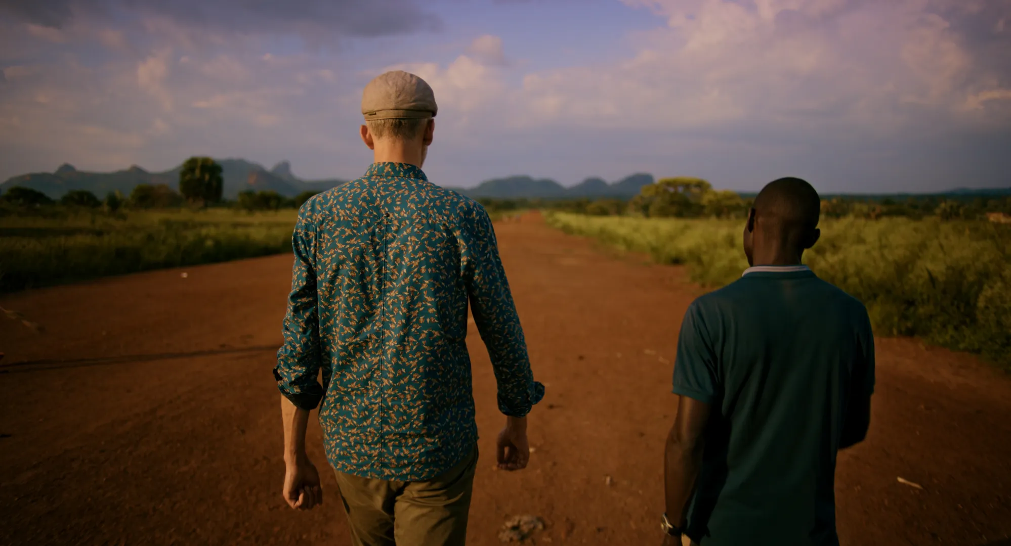
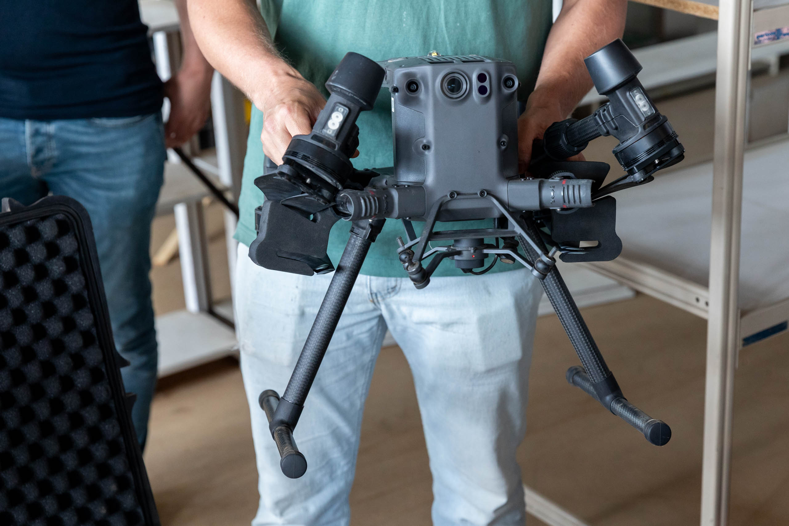
With the award’s support we have carried out extensive measurements using a mobile lab in the African savannas, principally in Botswana, South Africa, Zambia and Mozambique, using drones to analyse wildfires up close. In advance of a planned fire, we flew drones over the area to get a detailed picture of the vegetation, and we also performed ground measurements. During the fire we sent drones through the smoke to discover the composition of the fire’s emissions. Afterwards we flew drones one more time over the same area to analyse how the vegetation had been changed by the fire.
One of the greatest challenges is that we don’t yet fully understand the exact relationship between all the gases emitted during a wildfire. When you do a detailed analysis of fire emissions it turns out to involve hundreds of different gases, some of which are present in only very small quantities. The precise composition of these gases has seldom been systematically researched. Our measurements allowed us to further refine our database, which meant that we and other researchers can perform improved analyses and carry out new studies. Fundamentally, this is what I’ve been doing for the last twenty-five years: continually adding new and more complex data so that we can better understand wildfires and their role in the climate system. Although the improvements are usually only incremental, longer measurement series also regularly yield entirely new insights.
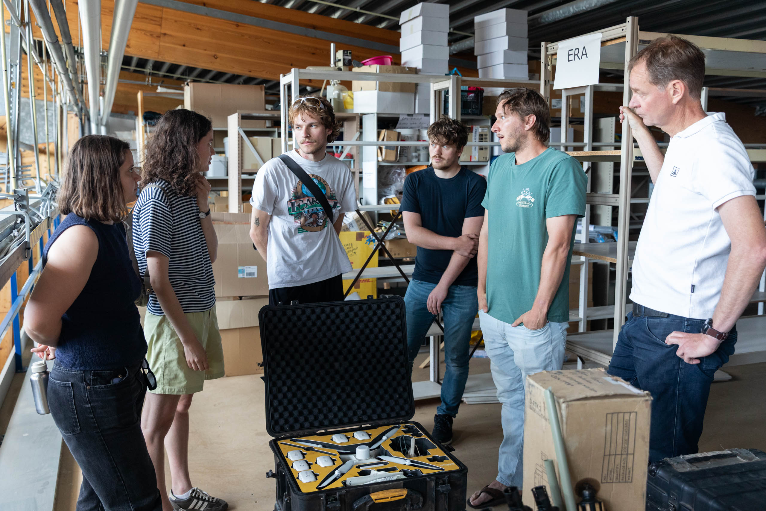
So you built a mobile laboratory to do these measurements. Could you tell us more about it?
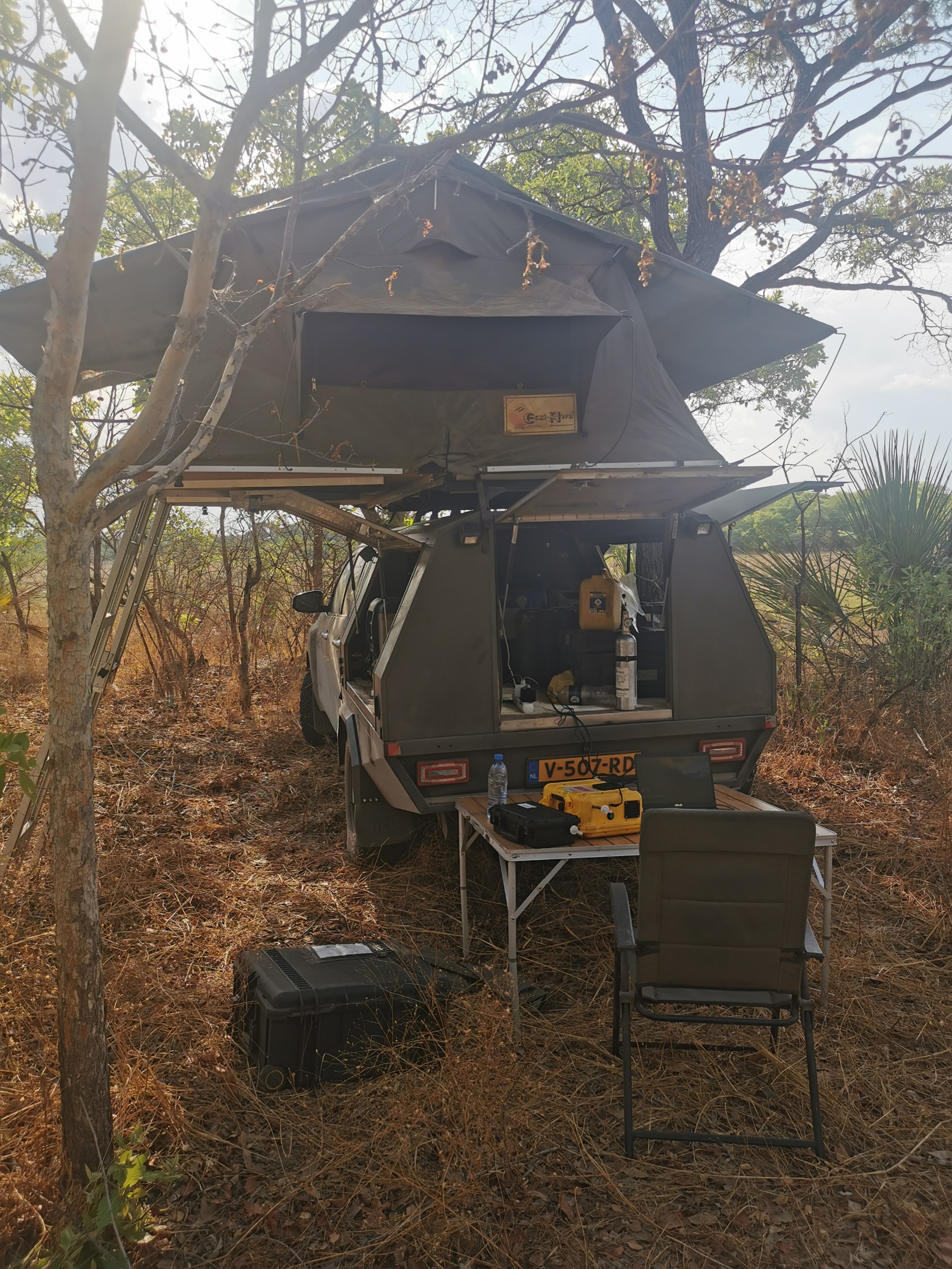
Since our measurements had to be made at lots of different locations, and often in remote and inaccessible areas, in the Netherlands we turned an all-terrain truck into a mobile working and sleeping unit. We converted the cargo area into a space in which we could do our analyses and recharge and store our equipment, and on top of the truck we put a tent to sleep in.
The truck was then shipped to Namibia, from where the PhD students Roland Vernooij and Tom Eames drove, over several years, over fifty thousand kilometres through southern Africa. That sounds adventurous, and sometimes it was, because their fieldwork definitely involved some risks. Political upheavals sometimes meant having to temporarily discontinue their research, and one of the researchers also caught malaria. At one point the superstructure shook loose from the truck, after they’d travelled thousands of kilometres on unpaved roads. But despite these setbacks and risks they were able to collect an enormous amount of new data, in a great many different places, from wildfires in open grasslands to dense tropical forests.
How did you manage to be at the right place at the right time during a savanna wildfire?
Before starting this research, we were in close contact with colleagues in South Africa, and that meant we could often link up with existing experiments. In Mozambique we even gained access to a large part of a national park, where we were allowed to carry out controlled fires at locations where fire control would already be present in that season. These were areas of about a square kilometre, and sometimes even bigger.
We were also fortunate in that we could work there together with colleagues from Australia. Since Australia also has savanna, they’re very interested in how savanna should be managed. Savanna regions have wet and dry seasons, and fires help to keep the savanna healthy. It makes a lot of difference whether a fire occurs early or late in the dry season. At the start of the dry season the vegetation is still relatively green and moist, so fires are less severe. Towards the end of the dry season, however, everything is completely dried out and fires can be extremely intense. The fieldwork we did later in the dry season had to be done with the greatest care: a little wind could very quickly spread a fire.
Thanks to the research in Mozambique and Botswana we were able to take measurements for both early and late dry season fires. We used this data to further improve our database; at the same time we shared our data with our Australian colleagues, which gave them better insight into the differences in emissions between early and late dry season wildfires. The Australian colleagues were most interested in understanding the consequences for biodiversity and the amount of biomass being burned, while we focused on the gases emitted by a fire and how these varied across time and space. This collaboration was an enormous help in carrying out a large number of measurements, partly because our Australian colleagues already had a good network in the region.
The call for nominations for the 2027 Ammodo Science Award for Fundamental Research just opened. Why is it important to continue supporting fundamental scientific research?
There is currently a great deal of interest in developing climate models with the help of big data and machine learning, and in the climate research field this development is taking some big steps. The next ambition is to develop climate models that do not just process satellite data, but also independently predict wildfires. Although this kind of research is very promising, we have also seen that it is running up against limitations because of the lack of validation data. At the same time, the very foundations of these models – the long-term global measurements and datasets on which these models rely – are under threat from lack of funding. Even the most advanced models can only function thanks to reliable field and satellite data and well-maintained databases. No matter how many impressive satellite observations and climate models we have, the absence of calibration and validation data, means there will always remain large uncertainties.
Funding is particularly hard to find for this essential, but often less visible work, such as the collection, checking, and management of data. Thanks to the Ammodo Science Award we’ve been able to map the specific emissions of wildfires with much greater precision and with many more variables. This kind of fundamental data ultimately forms the foundation of better climate models, new insights, and unexpected discoveries.
Published on 16 June 2026.
Photos: Florian Braakman